
Dive Area
It is the only island in the region called Dişibilmez or Aşı Bay.
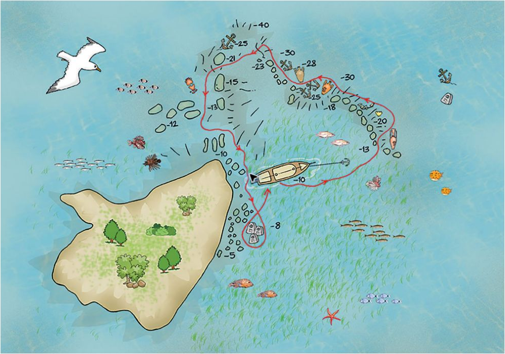
There is a fixed mooring if it is visible to avoid damaging with the anchor. There are two ancient anchors here. Swing back north to find the boat.
The island is completely surrounded by Posidonia sea meadows; After entering the water, go 30-40 m north over the rocky outcrops. The island looks like an aquarium when there are light currents.
Dive Profile
- Maximum Depth
- Average Depth
- Level
- Certified divers of any level.
- Current
- Visibility
- Dive Duration
- 45-50 min
Dive Briefing
- Location
- There is a fixed mooring if it is visible to avoid damaging with the anchor. There are two ancient anchors here. 36.41.966N 28.40.118E
- Entry
- There is a fixed mooring if it is visible to avoid damaging with the anchor.
- Route
- After seeing the broken amphora pieces, turn left and go down to a depth of 20-25m. Here you can see dozens of concretions of amphorae partially broken or fully formed. After taking the wall to your left and going for a while, you will leave the sandy area behind and reach the rocky area. In the rocky area, you can see groupers, bogues, lionfish, wrasses, octopuses, morays and many more species of fish. Especially if you are diving in August or September, millions of sand smelt will surround you. Start ascending heading shallower and you reach the island, maybe spotting the ancient floor tiles, turn left and go a little further; you will see a stack of stone anchors from thousands of years ago.
- Depth
- The island is completely surrounded by Posidonia sea meadows; After entering the water, go 30-40 m north over the rocky outcrops. After seeing the broken amphora pieces, turn left and go down to a depth of 20-25m.
- Current
- Visibility
- Marine Life
- Safety
- Exit
- Swing back north to find the boat.